
Ground-penetrating radar (GPR) is a geophysical method that uses radar pulses to image the subsurface. This nondestructive method uses electromagnetic radiation in the microwave band (UHF/VHF frequencies) of the radio spectrum, and detects the reflected signals from subsurface structures.

Our Services
Our technicians carefully evaluate and investigate the reflected signals displayed on the LCD screen in real-time, mapping out all findings directly on the surface so you can proceed with your project immediately and safely.
*3D Scanning and Imaging Available.
Concrete Imaging & Scanning
Locating post-tension cables, determining safe core drilling and cutting locations, rebar maping, deterioration and voiding, PEX, slab thickness and concrete encased utilities.
Bridge Deck Inspections
Locating rebar, post-tension cable mapping, deterioration and voiding, and delamination detection.
Recent Projects

Eugene, OR
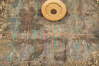
Locating a clear location for new roof drains to be cored in.
Green lines indicated center of hollow core, clear of structural steel. Red indicated tensioned structural steel. Orange indicated steel in topping slab, non structural.

Example of Hollow Core Slab

PeaceHealth Springfield, OR
Verifying previous core locations avoided structural steel.